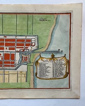
亞洲, 地圖 - 巴達維亞; N. De Fer - Plan de Batavia - 1681-1700
編號 85302241

編號 85302241
"Portugal and Algarbia"
Antique hand-coloured map titled 'Portugalliae et Algarbia'. Striking example of Schenk's rare map of Portugal, with the coats of arms of Portugal, Algarbia and a Spanish sailing vessell in the cartouche.
Peter Schenk the Elder (1660-1711), was a renowned Dutch engraver, cartographer, and publisher. He was born in Elberfeld, Germany, but spent most of his career in Amsterdam, where he collaborated with notable cartographers such as Gerard Valck. Schenk is best known for his detailed maps and atlases, as well as his high-quality prints and engravings. His work had a significant impact on cartography and printmaking in the late 17th and early 18th centuries, and his maps are still highly regarded by collectors today.
Dimensions:
52 cm x 60 cm
Medium:
Engraving
Artist or Maker:
Peter Schenk
Date:
1700
Condition Report
This work is in good condition overall. Please review the images carefully for condition and contact us with any questions.
This item is professionally protected by handmade packing.
The Certificate of Authenticity is included.