very well packed. tks.
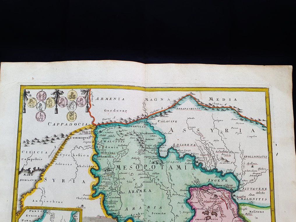
Zobacz tłumaczenieAzja, Mapa - Azja Mniejsza, Irak, Syria, Iran, Bliski Wschód; Christopher Weigel & David Kohler - Mesopotamiae, Assyriae, et Babyloniae Tabula - 1701-1720
Nr 85615333


Questa Mappa Geografica, è un'incisione su rame originale del 1720 (XVIII° Cen).
Trattasi dell'edizione Latina della fantastica opera di WEIGEL, edita da D. KOHLER sulla Geographia Antiqua.
La mappa in questione, proviene dalla bellissima opera, dal nome di: "Descriptio Orbis Antiqui in XLIV Tabulis Exhibita a IO. DAVIDE KOELERO ...... a NORIMBERGA, 1720."
Grande mappa in 4° Grande, edita in GERMANIA, con ottima coloritura originale, ampi margini, e geograficamente ben dettagliata in ogni punto.
Condizioni: le condizioni sono veramente molto buone come da foto.
Le misure complessive della mappa sono: Cm 48 X 39
Era
1400-1900
Liczba przedmiotów
1
Kraj
Azja
Specyfikacja geograficzna
Azja Mniejsza, Irak, Syria, Iran, Bliski Wschód
Producent / wydawca mapy
Christopher Weigel & David Kohler
Okres
1701-1720
Tytuł mapy/ książki
Mesopotamiae, Assyriae, et Babyloniae Tabula
Stan
Doskonały stanie
Technika
Miedzioryt
Seria
Ręcznie kolorowy grawer miedziany wielkości folio
Kolor mapy
Współcześnie ręcznie malowana
Wysokość
48 cm
Szerokość
39 cm
Liczba komentarzy: 1906 (468 w ciągu ostatnich 12 miesięcy)
- 464
- 4
- 0
Item perfectly described; it was well packaged, and it arrived quickly. Highly recommend seller.
Zobacz tłumaczenieGrazie bella mappa
Zobacz tłumaczenieThanks for this beautiful map...
Zobacz tłumaczenieItem exactly as described. Highly recommended vendor.
Zobacz tłumaczenieSnel verzonden. De kaart is in goede staat!
Zobacz tłumaczenieBonne transaction . Merci
Zobacz tłumaczenieExcellent map. Very quick delivery. Very well packed. Thank you! A+++
Zobacz tłumaczenieAll perfect as always!! Thank You!
Zobacz tłumaczenieUna bella carta geografica di fine Settecento dell'intero centr'Italia; valido l'imballaggio e buoni anche i tempi di spedizione.
Zobacz tłumaczenieOttimo grazie
Zobacz tłumaczenieSchnelle Lieferung, alles bestens!
Zobacz tłumaczenieThanks very much...Beautiful...No problem at all..EG...
Zobacz tłumaczenieMolto bella e fresca grazie
Zobacz tłumaczenieKaart ok
Zobacz tłumaczenieHo ricevuto in breve tempo il mio acquisto. Felicissima, e ho ottenuto un ottimo servizio
Zobacz tłumaczenieTout est parfait !!! merci Franck
Zobacz tłumaczeniethank you very much for all, beautifull maps, super quality shipping
Zobacz tłumaczeniethank you very much for all, beautifull maps, super quality shipping
Zobacz tłumaczeniePerfect, and excellent care & attention to detail in packaging! I will be following closely to see what else you have for sale
Zobacz tłumaczenieExcellent, as described and packed meticulously with care. This is 2/2 excellent sales & deliveries from this seller, highly recommend!
Zobacz tłumaczenieExcellent maps!!!
Zobacz tłumaczenieLiczba komentarzy: 1906 (468 w ciągu ostatnich 12 miesięcy)
- 464
- 4
- 0
very well packed. tks.
Zobacz tłumaczenie