Azja, Mapa - (PARTIA 3) Morze Północne / Rosja / Syberia / Morze Lodowate / Morze Kaspijskie; La Haye / P. de Hondt / J.N. Bellin - Carte du Detroit de Waeigats -- Carte des Pais Habites par les Samojedes et Ostiacs -- Partie de la - 1721-1750
Nr 85362039
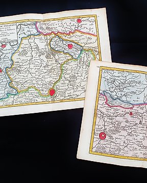
![Ameryka, Mapa - Ameryka Środkowa / Meksyk / Jukatan / Tabasco; La Haye / P. de Hondt / J.N. Bellin - [Lot of 2 maps] Carte de l'Empire du Mexique / Plan de Port Royal - 1721-1750](https://assets.catawiki.nl/assets/2024/6/17/0/8/a/08ac64df-f939-43be-9a40-7668649d9081.jpg)
Nr 85362039
Questo LOTTO di 2 Mappe Geografiche, sono un'incisione su rame originale del 1747 (XVIII° Secolo).
Trattasi dell'edizione nuova ed aggiornata del BELLIN & PREVOST, editatra il 1747 ed il 1788 ca. nella sua rara Opera, che porta il nome di: "HISTOIRE GENERALE DES VOYAGES....... AMSTERDAM, 1747".
Belle Carte Geografiche, edite in OLANDA, con ottima inchiostratura ed acquerellatura fantastica, e considerato l'anno di edizione, è geograficamente ben dettagliate in ogni punto.
Condizioni: le condizioni sono più che buone, come da foto
Le misure complessive della mappa più grande sono: Cm 38 X 26
Le misure complessive della mappa più piccola, sono: Cm 26 X 20
Jak kupować w serwisie Catawiki
1. Odkryj coś wyjątkowego
2. Złóż najwyższą ofertę
3. Dokonaj bezpiecznej płatności