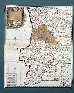
Portugal, Atlas; Peter Schenk - Portugal and Algarbia, Mare, Hispa, Nicum, Part of the Kingdom of Gallaeciae - 1681-1700
Nr. 84986339

Nr. 84986339
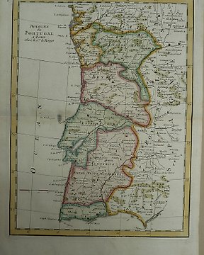
«Carte des Royaumes de Portugal et D'Algarve»
This hand-coloured map is from the Rizzi-Zannoni’s «Atlas Géographique» The work was published in Paris, 1775.
Giovanni Antonio Rizzi-Zannoni (1736–1814) was a distinguished Italian cartographer and geographer. He worked primarily in France, where he became renowned for his detailed and accurate maps. Among his notable works are the "Atlas géographique de toutes les parties du monde" and the "Atlas de l'Europe," which included maps of various regions of Europe and the world. His maps were highly respected for their precision and artistic quality, and they continue to be valuable to historians and collectors.
Dimenssions
42,7 cm x 32 cm
Artist or Maker
Giovanni Antonio Rizzi-Zannoni
Medium
Hand-coloured engraving
Date
1775
Condition Report
This work is in very good to excellent condition overall. Please review the images carefully for condition and contact us with any questions.
This item is professionally protected by handmade packing.
The Certificate of Authenticity is included.
Zo koop je op Catawiki
1. Ontdek iets bijzonders
2. Plaats het hoogste bod
3. Veilig betalen