Everything worked well
Visualizza traduzioneEuropa - Francia / Nuova Aquitania / Bordeaux / Guyenne / Guascogna; J. Blaeu - Govvernement de la Gvienne & Gascogne - 1662
N. 85707125


In goede conditie. Vouw als uitgegeven. Enkele oudtijdse verstevigingen langs bladrand, ook enkele kleine onverstevigde scheurtjes. Enige ouderdomsverkleuring en vlekjes. Verso blank.
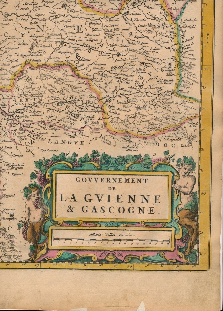
Grote en decoratieve kaart van de Bordeaux regio. De stad is linksboven te zien, vlakbij de monding van de rivier de Garonne. Bayonne, Toulouse en zelfs Pamplona, Spanje worden getoond.
De grote titelcartouche rechtsonder wordt geflankeerd door twee saters en omringd door druivenranken. Groepen putti in de bovenhoeken houden wapenschilden omhoog van verschillende provincies die in de regio te vinden zijn, hoewel veel ervan blanco zijn gebleven.
Joan Blaeu (1596-1673) was a prominent Dutch cartographer, a member of the famous Blaeu family of mapmakers.
He worked in Amsterdam and was known for producing some of the most detailed and beautiful maps of the 17th century.
Blaeu was appointed the official cartographer of the Dutch East India Company (VOC).
Atlas Major:
The "Gouvernement de la Guyenne & Gascogne" map is part of Blaeu's monumental work, the "Atlas Major" (also known as "Atlas Maior" or "Theatrum Orbis Terrarum").
The Atlas Major, published in various editions from 1662 to 1672, was one of the largest and most expensive atlases of its time, containing detailed maps of various regions of the world.
It was known for its high-quality engraving, elaborate hand-coloring, and detailed descriptions.
In goede conditie. Vouw als uitgegeven. Enkele oudtijdse verstevigingen langs bladrand, ook enkele kleine onverstevigde scheurtjes. Enige ouderdomsverkleuring en vlekjes. Verso blank.
Grote en decoratieve kaart van de Bordeaux regio. De stad is linksboven te zien, vlakbij de monding van de rivier de Garonne. Bayonne, Toulouse en zelfs Pamplona, Spanje worden getoond.
De grote titelcartouche rechtsonder wordt geflankeerd door twee saters en omringd door druivenranken. Groepen putti in de bovenhoeken houden wapenschilden omhoog van verschillende provincies die in de regio te vinden zijn, hoewel veel ervan blanco zijn gebleven.
Joan Blaeu (1596-1673) was a prominent Dutch cartographer, a member of the famous Blaeu family of mapmakers.
He worked in Amsterdam and was known for producing some of the most detailed and beautiful maps of the 17th century.
Blaeu was appointed the official cartographer of the Dutch East India Company (VOC).
Atlas Major:
The "Gouvernement de la Guyenne & Gascogne" map is part of Blaeu's monumental work, the "Atlas Major" (also known as "Atlas Maior" or "Theatrum Orbis Terrarum").
The Atlas Major, published in various editions from 1662 to 1672, was one of the largest and most expensive atlases of its time, containing detailed maps of various regions of the world.
It was known for its high-quality engraving, elaborate hand-coloring, and detailed descriptions.
Epoca
1400-1900
Paese
Europa
Specificazione geografica
Francia / Nuova Aquitania / Bordeaux / Guyenne / Guascogna
Creatore mappa / Editore
J. Blaeu
Periodo
1662
Titolo mappa / libro
Govvernement de la Gvienne & Gascogne
Condizione
Buone
Tecnica
Incisione in rame
Serie
Bell'esempio della mappa di Blaeu della regione di Bordeaux.
Colore della mappa
Colorazione a mano coeva
Altezza
45 cm
Larghezza
59 cm
2500 recensioni (7 negli ultimi 12 mesi)
- 7
- 0
- 0
Niets aan toe te voegen.
Visualizza traduzioneZending snel en uitstekend goed verpakt geleverd!
Visualizza traduzioneals beschreven in goede staat snel verstuurd en goed ingepakt. dank!
Visualizza traduzione


