Item exactly as described. Recommended vendor.
Fordítás megtekintéseEurópa - Németország / Svábország / Schwaben / Ulm / Konstanz / Seckingen / Rheinfeld / Waldshut /; De Fer - Le Cercle de Souabe, Plan de la Ville d'Ulm, Les quatre Villes Forestiers - 1701-1720
Nr. 88252639


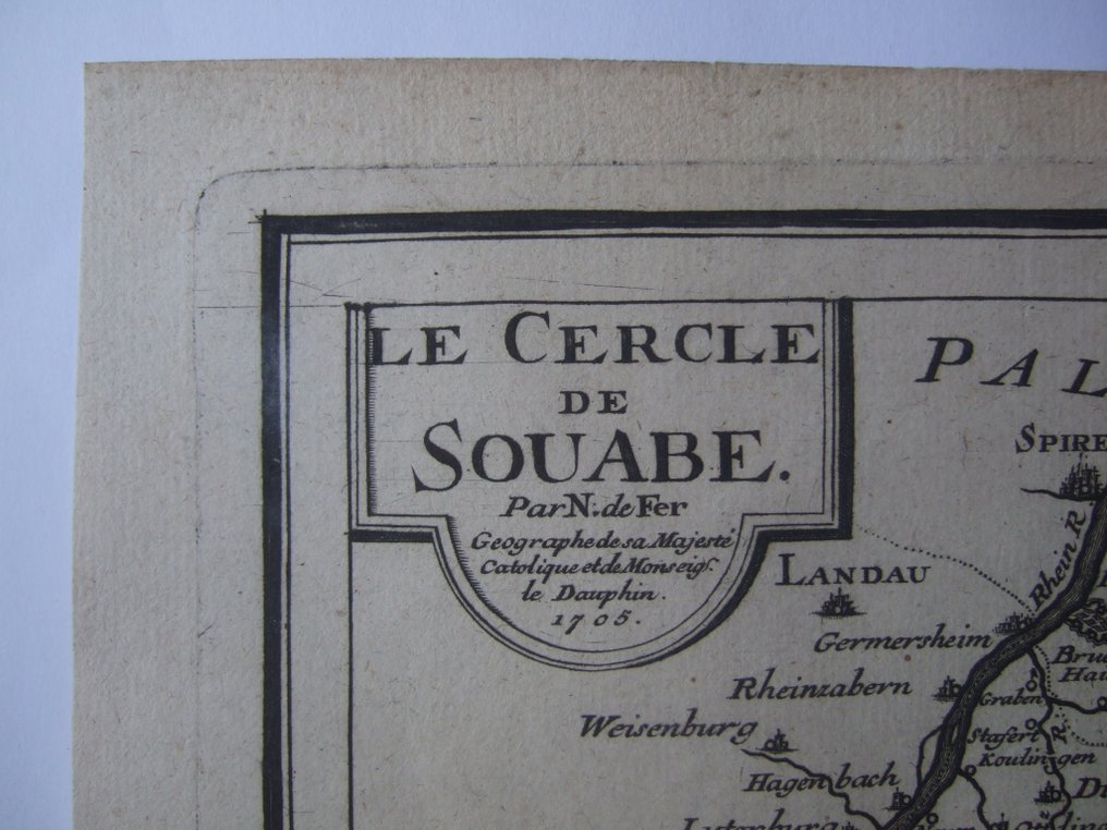


1705 dated, by De Fer ,one very detailed map of the Swabia Region in South-West Germany, + 2 sheets with altogether 6 Town/Fortification plans in the region. From his 'Atlas Curieux'
in generally fine condition
shipping by registered mail only
1705 dated, by De Fer ,one very detailed map of the Swabia Region in South-West Germany, + 2 sheets with altogether 6 Town/Fortification plans in the region. From his 'Atlas Curieux'
in generally fine condition
shipping by registered mail only
Korszak
1400-1900
Elemek száma
3
Földrajzi eredet
Európa
Földrajzi specifikáció
Németország / Svábország / Schwaben / Ulm / Konstanz / Seckingen / Rheinfeld / Waldshut /
A térkép készítője/ gyártója
De Fer
A térkép/ könyv címe
Le Cercle de Souabe, Plan de la Ville d'Ulm, Les quatre Villes Forestiers
Korszak
1701-1720
Állapot
Kiváló
Technika
Rézmetszet
Sorozat
1705-ös keltezésű, 3 nem mindennapi térkép, 6 várostervvel és egy általános térképpel a régióról
Térkép színe
Színezés nélküli térkép
Height
250 mm
Width
353 mm
76 visszajelzés (23 az elmúlt 12 hónap során)
- 22
- 1
- 0
Alles bestens geliefert, danke!
Fordítás megtekintéseFast - extremely well packed & protected - thanks
Fordítás megtekintéseThanks for all your care in delivery of our purchase.
Fordítás megtekintéseI very gratefully for the opportunity that you offered me to become in the position to have this great piece of history. Well preserved and carefully delivered. Thank you very much.
Fordítás megtekintésebeau produit bien emballé merci
Fordítás megtekintéseVielen lieben Dank
Fordítás megtekintéseMerci pour cet objet et très heureux. Je déplore le transit postal ( trois semaines depuis l'arrivée en France) qui est vraiment nul en FRANCE. Je recommande. Guy
Fordítás megtekintéseAz eladó válasza
heureux de voir tout a passe bien enfin !
Fine maps, Fast shipping.
Fordítás megtekintéseItem received in due time and perfect condition
Fordítás megtekintéseEnvoi rapide et soigné, cartes de qualité, merci !!!
Fordítás megtekintéseperfetto
Fordítás megtekintéseSuperbe! Merci...
Fordítás megtekintéseThank you for your delivery.. Unfortunately, my address was written a bit illegible and there was a problem with fast delivery. What's more, the letter was not well protected, That's a pity!
Fordítás megtekintéseThank you!
Fordítás megtekintése76 visszajelzés (23 az elmúlt 12 hónap során)
- 22
- 1
- 0
Item exactly as described. Recommended vendor.
Fordítás megtekintése