Catawiki actualiza constantemente su tecnología. Actualmente, estás utilizando un navegador obsoleto. Para optimizar tu experiencia de navegación, actualiza tu navegador.
Cookies
Puedes configurar tus preferencias de cookies utilizando los botones de abajo. Puedes actualizar tus preferencias, retirar tu consentimiento en cualquier momento y ver una descripción detallada de los tipos de cookies que usamos nosotros y nuestros socios en nuestra Política de cookies.
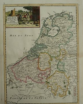
Países Bajos, Mapa - Países Bajos con Nueva Holanda/Amsterdam y Batavia; Cornelius Kribber - Hollandia - 1751-1760